Although geographic information systems (GIS) have been widely used by businesses for the efficient use of geographically distributed resources, marketing, and so on, the importance of personal and daily use of GIS will become paramount. This research provides a new framework for the Cognitive Geographic Information System (CGIS) leading to the integration of maps and geographic information contents through their cognitive attributes; we have developed a geographic information system based on this framework. The vast amounts of geographic information stored available through the WWW will change the process of geographic information retrieval. For example, conventional GISs cannot well answer questions such as “Where can we eat a Kyoto-style meal and see beautiful red and yellow leaves near the Kyoto Station?” The integrated contents of geographic information available through the WWW does, however, provide sufficient information to users.
Foundation Model:
We assume that WWW users shared common notions of specific areas. This enables us to relate specific areas to specific notions using WWW contents. Nouns that have important roles in WWW pages are extracted by web mining techniques. The noun space composed of these nouns is divided into two spaces, Geographic Word space (G-Words) and Non Geographic Word space (N-Words). Geographic information retrieval and analysis can be interpreted as information retrieval and geographic analysis utilizing the relationships that exist among WWW space, Geographic Word space and Non Geographic Word space (Fig. 1).
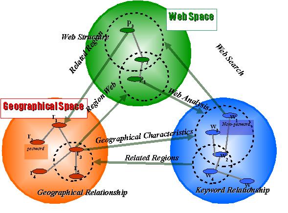
Fig. 1 Relationships among WWW space, Geographic Word space, and Non Geographic Word space
The prototype system, KyotoSEARCH-I (Fig. 2), integrates maps, place-names (areas) and the WWW seamlessly. Users of this system move among these three layers for information retrieval. The features of the system are the interactive map interface and the conceptual navigation interface. Users can access any WWW content through the information networks in the geographic information space and conceptual space by using these interfaces.
The unique characteristic of the system is its combination of the map interface and the conceptual navigation interface. Users can access the information bymoving between keyword sets (G-Words and N-Words) (Fig. 2). If a user indicates a location name on the conceptual navigation interface, the region including the location name will appear on the map interface. If a user indicates a keyword other than a location name, a list of related WWW pages will be displayed for retrieving detailed information from the WWW. This system publicly accessible on the WWW and is being widely used. This system is written in Java for portability and so can be easily used for other cities.
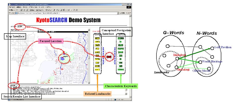
Fig. 2 The user interface of KyotoSEARCH-I (left) and
focus transitions in the conceptual navigation interface (right)
Publications:
Ryong Lee, Hiroki Takakura and Yahiko Kambayashi. Visual Query Processing for GIS with Web Contents. The 6th IFIP Working Conference on Visual Database Systems,2002.
Ryong Lee, Yohsuke Inoue, Taru Tezuka, Naoharu Yamada, Hiroki Takakura, and Yahiko Kambayashi. Kyoto SEACH: A Concept-based Geographic Web Search Engine. Proceedings of 2002 IRC International Conference on Internet Information Retrieval, pp.119-126, 2002.
Contact:
Taro Tezuka (tezuka at dl.kuis.kyoto-u.ac.jp)
Yusuke Yokota (yyokota at i.kyoto-u.ac.jp)
Dept. of Social Informatics, Kyoto University